
Rivers Never Dry
26 April 2026
This project is being developed as part of the Computational Arts-Based Research and Theory module on the MA Computational Arts programme. The final work will be developed further for exhibition at the MA Festival, the programme's concluding degree show.
Context
London's rapid urbanisation during the Industrial Revolution buried many of its rivers underground (Doberski, J, 2024). Repurposed as sewers and erased from the surface, these waterways disappeared from sight yet continued to persist through ecology, infrastructure, and spatial memory.
Tracing the River Effra and the River Heathwall, which were culverted in the mid-nineteenth century like other lost rivers, I encountered multiple traces of its former presence: parks occupying land too damp for habitation, willow trees quietly marking the former channel, buildings conspicuously avoiding the buried riverbed, stink pipes emerging awkwardly between roads and buildings (Newman, 2016). Though invisible, the river remained everywhere, a latent system continuing to shape and influence the city above it.
Rivers Never Dry investigates the hidden existence of buried urban waterways as entangled ecological, infrastructural, and computational systems.
Through field research, speculative visualisation, and data-driven artistic practice, the project examines how rivers continue to exist despite physical erasure, and how data itself may carry residual memory, ecological consequence, and social history.


A map by David Western showing the Battersea area in 1840. Heathwall can be seen in the map

Notes from the Heathwall walks
Journals
05 February 2026: Visiting Heathwall
Drawing on memories of a cycling tour organised by Open City with a historian Jon Newman in August 2025, I decided to revisit the route. The tour had run from Clapham Junction to Vauxhall, but as I had spent most of it cycling and only stopped briefly to listen to the Jon's commentary, I couldn't recall the exact route. I headed out without a detailed plan, relying instead on the map illustrations in The Heathwall: Battersea's Buried River — a book I had bought on the tour — to navigate, finding my way through a rough sense of direction and fragments of memory from that day.
The simple conclusion was this: without expert guidance, it was very difficult to tell that this had once been a river, or to know what any given marker or feature might signify. I regretted coming out so unprepared. The few things I felt reasonably confident reading as traces of the river were the steep descent turning from Latchmere Road into Heathwall Street, the slope falling northward from Lavender Hill, and the willow trees scattered along the way. Even these felt uncertain, though. With the trees largely bare at that time of year, identifying the species was harder than it might otherwise have been.
I walked as far as Wandsworth Road before stopping. I got tired, and didn't continue beyond that point.


Notes from the conversation with Gero
2 March 2026: A Conversation with Gero
I met Gero, a PhD student, at a Goldsmiths Computing department event. He had been researching the Thames and tidal patterns for several years, and it seemed likely he could offer perspectives I hadn't encountered, so I reached out to him afterwards. Gero's research focuses primarily on the Thames, tidal patterns, and communities around the Thames Estuary — a different scope from my own, which centres on the smaller lost rivers that once fed into the Thames. Even so, there was plenty to discuss: sewage infrastructure, the history of London and the Thames, and the environmental and social issues entangled with London's rivers.
The most valuable things I took from the conversation were three: don't set aside geography and mapping; make use of other artists' work where it's relevant; and an introduction to the field of psychogeography. These advices all felt well-founded, so I began paying closer attention to the relationship between topography and the river, and started reading into psychogeography.
25 March 2026: A Conversation with Jon
I had kept Jon's contact details from the cycling tour in August. I got in touch to let him know I was researching lost rivers, and asked whether he might be available for a brief meeting. He agreed, and we were able to speak over a video call.
A few things I learned from the conversation: Jon is an archivist at Lambeth Archives, and it was through that work that he came across old maps of the Lambeth area and developed a natural interest in them. The archive is open to anyone, free to visit by appointment. I'm planning to go myself at some point to look through the maps.
On the question of why he runs the tour by bike rather than on foot: tracing an old river on foot, even a relatively small one, can easily take several hours. Cycling, he said, also gives a more physical sense of the terrain. You become conscious about the contours of the land in a way that makes the river more present.
The tours draw a mixed crowd in terms of age and background, though he mentioned that older men with a professional background in water and drainage engineering tend to show a particular interest.


The recorded gpx data was mapped onto Google Maps for visualisation.

Notes from the River Effra walks
15 April 2026: Walking as Cartography, River Effra
Alongside the walking itself, I drew inspiration from artists such as Masaki Fukihata and Jeremy Wood, who used GPS — then an emerging technology — as a medium for experimental map-making and artistic practice. Taking a similar approach, I decided to collect data by physically walking the route of the River Effra from its source down to the Thames. The method was simple: my own two feet, a camera around my neck, and an Apple Watch on my wrist, tools that I already have or easy to find. A river shapes terrain over long periods of time, and is itself shaped by it in return, so I concluded that the investigation of this subject could not set aside topography and the land. Walking the terrain, I would measure elevation, speed, heart rate, and steps, and see what the data might yield.
This walk was planned with considerably more care than the Heathwall walk in February. Unlike the Heathwall, the Effra still retains natural traces of the river in its upper reaches, and the gradient from source to mouth is more pronounced — it doesn't only pass through dense urban areas, which made it better suited to data collection. The full length of the Effra, from Westow Park near Crystal Palace to Vauxhall, is generally recorded as somewhere between 10 and 13 kilometres.
Setting a start and end point in Google Maps gives you the fastest and most efficient route. That wasn't the point of this exercise: the aim was to follow the course of an old river, which required a different approach. I began by reading and walking from the text in Jon Newman's book, but after losing my way three times, I switched to plotting dozens of intermediate stops in Google Maps and navigating between them.
My original expectation had been to capture body data that responded to the terrain. A heart rate rising with the gradient, walking pace shifting accordingly. But the unplanned detours, the stops to photograph and research along the way, gradually pulled the walk away from any precise data-collection framework and towards something more like ordinary walking.
The full journey from Crystal Palace through Norwood, Dulwich, Brixton, and Oval to Vauxhall took seven hours in total. Excluding two rest stops, the active walking time was 3 hours 40 minutes, covering a recorded distance of 14.38 km with a total elevation change of 229 metres. Somewhere along the hard asphalt stretches past Brixton, the thought of giving up crossed my mind — but a river flows on unbroken to the sea, and so I continued.
A few notes made while walking above the buried Effra:
Getting lost so many times was frustrating, but perhaps that is part of the beauty of walking. Each wrong turn brought something unexpected — new streets, new observations. After losing my way repeatedly in the upper reaches, I realised that the simplest guide was to follow the general downhill lie of the land.
London is largely flat, and the Effra doesn't have dramatic elevation change, so the body data may not vary greatly along the route. A few findings:
From Crystal Palace to the start of Dulwich, the terrain was noticeably hilly and greener, with more complex, winding streets rather than the wide straight roads of inner London.
From Brixton to the Thames, the land levelled out entirely and the environment became far more built-up. Any traces of the Effra became increasingly difficult to read.
The weather shifted four times over the course of the walk: cloudy, then rain, then sun, then cloud again.
Cycling upstream from the Thames mouth might yield more responsive body data, as the gradual incline would be more physically felt on a bike than on foot.
Walking at a slow pace made it possible to observe the vegetation properly. A few types of trees appeared repeatedly along the route.
The air smelled fresh at the start — it had rained the night before. It was a reminder that this kind of walking practice is shaped considerably by the outdoor environment: season, weather, even the smell of the air on a given day.
As I moved deeper into the city, both the natural traces and the urban markers faded together. The scent of spring that had been present in the upper reaches was gone, and so were the artefact traces, the stink pipes and street shaped as rivers had disappeared too.


Data into 3D: What the data tells you
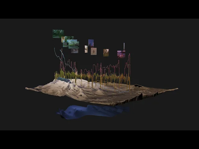
From the data collected via Apple Watch, I selected what I considered the most meaningful dataset and exported it as CSV files using the Auto Export app, downloaded from the App Store. The extracted data included fields such as Timestamp, Latitude, Longitude, Altitude, Vertical Accuracy, Horizontal Accuracy, and Speed. My intention was to experiment with mapping this data onto a map using the timestamp and location fields.
I uploaded the CSV and GPX files to Claude AI and prompted it to draw three lines in a 3D environment based on the data. The resulting Python script was entered into Blender's scripting panel, and I was able to produce an output close to what I had envisioned.
Once the three lines were drawn, the next requirement was a map of the actual London terrain beneath them. Rather than a conventional map dense with street names and building labels, I wanted something that would clearly convey the topography at a glance. The approach I chose was to apply a heightmap texture to a flat plane in the 3D environment.
Since I needed a heightmap covering only the specific area of interest, broadly available heightmap textures of the whole of the UK or Greater London were not suitable. Instead, I used a Google Maps link converter made by Arnaud Vojda to download a map image of the relevant area in south London.

When the heightmap was applied to a flat plane to generate the terrain, and the data-driven curves from the Apple Watch were placed on top, I could clearly see that I had walked along lower ground, following what appeared to be a valley. Having previously viewed the route only through Google Maps and illustrated maps, this was the moment my walking practice became visible all at once in a three-dimensional space.
The curves generated from walking speed and heart rate appeared comparatively noisy, with little obvious relationship to elevation. Using these three curves as a basis, I then attempted to redraw the terrain itself. Every variation in my pace, slowing to observe trees and flowers, retracing sections hurriedly after losing my way, became a river. Rather than using the heightmap, I multiplied the rate of change in the body data with the change in elevation values, and applied the result to the flat plane. The key difference here was that instead of pushing the surface upward where data difference was greatest, I inverted this, allowing the surface to sink downward. In doing so, a kind of erosion occurred within the virtual digital environment, much as rivers have carved into landscapes over thousands of years.

This can be read in relation to the river's current condition: buried beneath the ground and repurposed as part of the sewage system. Though it has lost its natural function underground and is gradually being forgotten, the river continues to exert influence above the surface, shaping the lives of both people and ecosystems. Through urban development, water quality issues, and political pressures, it persists both below and above ground in countless ways. This work proposes a new kind of terrain that speaks to that continued, layered existence. Mapping is rooted in wayfinding: we begin by making sense of our surroundings so that we can go somewhere (O'Rourke, 2013). That wayfinding can also mean finding the way to become completely and utterly lost. In this project, it is a wayfinding towards the lost rivers, and an exploration of where that path might lead.
Reflection and Future Development
At the current stage, the work has focused on producing the 3D model. The next phase will involve refining the model and moving it into a real-time environment. By transferring it into a platform such as Unity and adding mouse controls and UI elements, viewers would be able to rotate and explore the model in real time, navigating it layer by layer. This would allow for a more immersive experience.
The section where the Effra meets the Thames at Vauxhall currently has the Tideway Tunnel running beneath it. Storm discharge events occur at this point, and the relevant data is accessible via the Thames Water API.
The reason this discharge data has not been actively incorporated at the current stage is twofold: no discharge events have occurred over the past several months, and a suitable method for integrating the data meaningfully into the project has not yet been determined.
References
Doberski, J. (2024) The Science of Sewage: What Happens When We Flush. Gemini Books Group.
Fujihata, M. (1994) Impressing Velocity. [Artwork] Available at: http://www.medienkunstnetz.de/works/impressing-velocity/ (Accessed: 23 April 2026).
Lost rivers of South London cycling tour (2026) Open City. Available at: https://open-city.org.uk/events/river-10 (Accessed: 5 February 2026).
Newman, J. (2016) River Effra: South London's Secret Spine. Signal Books.
O'Rourke, K. (2013) Walking and Mapping: Artists as Cartographers. MIT Press.
Wood, J. (2010) Traverse Me. [Artwork] Available at: http://www.gpsdrawing.com/maps/traverse-me.html (Accessed: 23 April 2026).
All photographs not otherwise credited are taken by the author.